 Douglas Point, Charles County
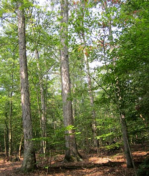
Along the Potomac River in southwestern Charles County lies the largest remaining area of mature hardwood forest for miles around. Douglas Point Natural Area encompasses over 800 acres of forest and the Potomac River shoreline along Blue Banks and Wades Bay. Trails lead visitors past natural springs, where groundwater flows out of wooded slopes to form mossy seeps, and into areas that are beginning to show characteristics of old growth forests. Large trees and the well-defined shrub, understory and overstory layers are important habitat characteristics of old forests, providing a variety of nesting and feeding areas for wildlife. In spring, the forest is filled with blooming wildflowers and the songs of birds. Along the river, bald eagles can be seen circling overhead or chasing an osprey passing by with a fish in its talons. Several trails lead to the river; visitors can enjoy the view, take a picnic lunch, or look for fossils along the beach.
 Douglas Point Natural Area includes portions of several different public properties and is managed by a team of state and federal land managers. The
Nanjemoy Wildlife Management Area is managed by the Wildlife and Heritage Service, Department of Natural Resources. The Douglas Point Special Recreation Management Area is managed by the United States Department of the Interior, Bureau of Land Management, Lower Potomac Field Station. The Potomac Heritage National Scenic Trail and the Star-Spangled Banner and Captain John Smith Chesapeake National Historic Trails (National Park Service) connect this area by land or water south to Virginia and north to Pennsylvania.
Douglas Point Natural Area includes portions of several different public properties and is managed by a team of state and federal land managers. The
Nanjemoy Wildlife Management Area is managed by the Wildlife and Heritage Service, Department of Natural Resources. The Douglas Point Special Recreation Management Area is managed by the United States Department of the Interior, Bureau of Land Management, Lower Potomac Field Station. The Potomac Heritage National Scenic Trail and the Star-Spangled Banner and Captain John Smith Chesapeake National Historic Trails (National Park Service) connect this area by land or water south to Virginia and north to Pennsylvania.
Fossil Findings: Past as Present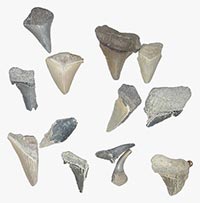
Evidence of former inhabitants from both ancient and more recent times can still be found. When a warm sea covered the area over 60 million years ago, the remains of clams, sharks, rays, crocodiles, and turtles were deposited in the Aquia geological formation. Through time, natural erosion of the river bank has released some of these remains, especially shells and shark's teeth. Fossils may be collected at low tide in rocks and sand along the river's edge, but
any fossils still embedded in the river bank should be left in place because they are protected by law.
Warblers and Milkvines and Satyrs, O My!

The large unbroken forest, dominated by white oak and chestnut oak, regularly supports 20 of the 25 species of Maryland birds that only nest in the interior of the forest, including wood thrush, worm-eating and hooded warblers, and whip-poor-will. Their presence here in high densities played a critical role in the National Audubon Society's designation of this area as part of the Nanjemoy Important Bird Area.
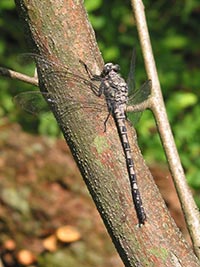
The woods also contain the rare angular-fruited milkvine (Matelea gonocarpos), which seems to thrive in the more neutral soils that gain calcium from underlying fossil shell material. Forested seepage wetlands, fed by groundwater and saturated year-round, and freshwater marshes support the Threatened Sely's sunfly (Helocordulias elysii) and rare gray petaltail (Tachopteryx thoreyi). The rare Carolina satyr (Hermeuptychia sosybius) flits along grassy forest trails, stopping to sip juices from rotting fruit, animal scat or tree sap.
 Click here for a Print Version of this map.
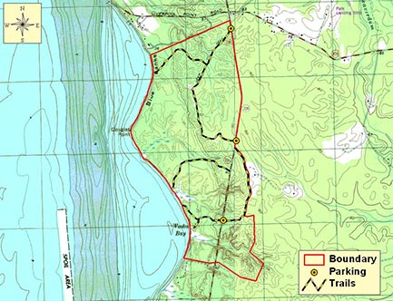
Douglas Point Natural Area
Special Note: Douglas Point Natural Area is used seasonally by hunters.
Directions
From Washington, DC: Travel I-95/495 (Capital Beltway) to Exit 3 at MD 210 (Indian Head Highway) and take it south towards Indian Head, nearly 18 miles. Just north of Indian Head, turn left to go east on MD 225. After 1.6 miles, turn right to go south on MD 224 (Chicamuxen Road). From here, travel 8.5 miles and turn right at the split with MD 344 to stay on MD 224, which is now called Riverside Road. Continue another 5.5 miles to the signed parking lots.
For more information on Douglas Point:
Potomac Heritage National Scenic Trail:
http://www.nps.gov/pohe/index.htm
Douglas Point Special Recreation Management Area:
https://www.blm.gov/office/northeastern-states/lower-potomac-field-station/douglas-point


Driving directions and aerial views open with Google Maps. For the aerial view button, if an aerial view does not open by default, click on the Satellite icon in the upper right corner and Google Maps will switch to an aerial view of the Natural Area.