North End, Worcester County
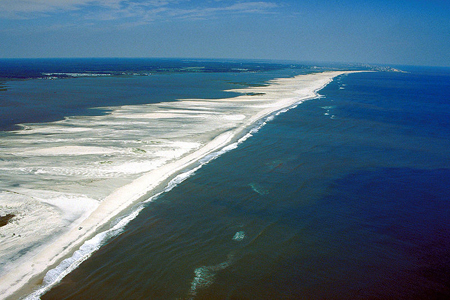 In a stunning contrast to the built-up beaches of Ocean City, the northern end of Assateague Island (known simply as the "North End" to many locals) contains a stretch of wild, nearly untouched beach. This section of the barrier island supports numerous rare species found nowhere else in Maryland, such as the plant seabeach amaranth (Amaranthus pumilus), federally Threatened and state-listed as Endangered. The open sandy beach shifts into protective dunes covered with American beachgrass and seaside goldenrod. The dune system later gives way to a maritime shrub forest then bayside salt marshes and sand flats. The landscape of the North End Natural Area is as dynamic as the nor'easters and hurricanes that regularly reshape the island, resetting succession. Between April and mid-August, the interior portions of the North End Natural Area and much of the bayside shoreline is closed to human use to protect sensitive breeding birds. Contact Assateague Island National Seashore for seasonal guidance on visiting the Natural Area. This dynamic landscape can be visited only by foot or small boat.
Most of the piping plover (Charadrius melodus) population in Maryland breeds in the North End Natural Area. Other rare birds which breed here include the Threatened least tern (Sternula antillarum) and the American oystercatcher. Sharp-eyed visitors may catch a glimpse of the white tiger beetle (Cicindela dorsalis media) as it scurries by in search of small insect and invertebrate prey. Piping plovers, least terns and white tiger beetles are all listed as either Threatened or Endangered species by the State of Maryland or the federal government. This area is managed by the National Park Service as part of Assateague Island National Seashore.
Sculpted by the Elements
 Interestingly enough, the North End Natural Area is one of the youngest geologic landscapes in Maryland. Wind, waves and coastal storms are constantly reshaping the landscape, requiring its wild residents to remain on the move. Plants found within this area are specially adapted to deal with salt sprays which normally would dry out and kill other vegetation
Project Sand Trap
Historically, sand that eroded from the beaches on the North End of Assateague Island would later be replaced with sand moving down from the north. However, formation of the Ocean City Inlet in 1933 and subsequent construction of the jetties that maintain the inlet have permanently interrupted this natural process. Between 1998 and 2002, a project was developed to annually replace the sand trapped by the Ocean City Inlet back onto the North End Natural Area's offshore sandbars. This nourishment, mimicking natural processes, must continue indefinitely in order to sustain the health of the North End ecosystem.
 Click here for a Print Version of this map.
Special Note: North End Natural Area is used seasonally by hunters.
Directions
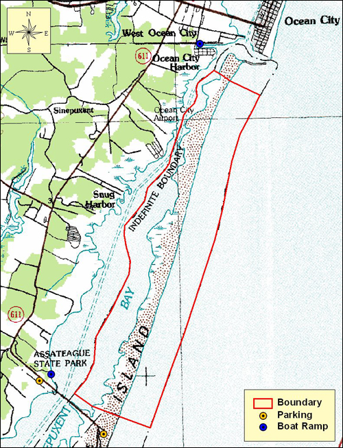
From Ocean City: Travel west on US 50 about 1.3 miles to MD 611 and turn left (south). Continue 8 miles to the end of MD 611. The North End Natural Area is a relatively remote area accessible only by foot or boat. There are no marked trails or facilities within this large Natural Area. To hike into the North End Natural area the most convenient parking is at Assateague Island State Park immediately to its south. Parking is also available at Assateague Island Visitor Center on the mainland with access to the North End via a 1.6 mile walk over the Verrazano Narrows hike/bike bridge and then north along the beach. The two nearest public boat ramps are the Assateague State Park boat ramp at the western end of the Route 611 Bridge and the West Ocean City boat ramp immediately west of the Ocean City inlet. Please respect all area closures while visiting the North End Natural Area.


Driving directions and aerial views open with Google Maps. For the aerial view button, if an aerial view does not open by default, click on the Satellite icon in the upper right corner and Google Maps will switch to an aerial view of the Natural Area.

Acknowledgments
Scenic View of Assateague. Photo by: Wikimedia Commons
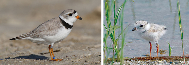
Wildlife Collage One: (left to right)
Piping plovers raise their young in flat, sandy areas where the ground is moist. Adults will feign �a broken wing to draw attention away from their chicks or nest when a predator may be threatening their safety. Photos by: USFWS
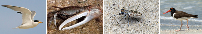
Wildlife Collage Two: (left to right)
The least tern breeds on the North End's sandy beaches along with the piping plover. These graceful birds plunge-dive into the water from great heights to catch small fish. Photo by: USFWS
Look for mud fiddler crabs among�the marsh grass at low tide. Males use their huge claw to impress females during courtship. Photo by: NOAA/Wikimedia Commons
During mid-summer the white tiger beetle tirelessly patrols the North End's beaches. Photo by: Chris Wirth
The large, birght bill of the American oystercatcher is perfectly designed to pry open the shells of oysters, clams and mussels Photo by: USFWS
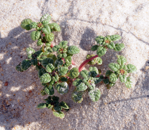
Seabeach amaranth brings a splash of color to the dunes. Their roots act as anchors and hold the loose sand in place to slow erosion. Habitat loss �and grazing are its greatest threats. Photo by: Paula Becker
